A healthy forest for the future thanks to sustainable forestry: reforestation ✓ tree species selection ✓ climate adaptation ✓ biodiversity ➤ learn everything you need to know about healthy forest use!
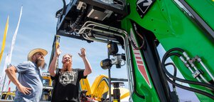
Digitalization is one of the most forward-looking trends in forestry and plays a central role at INTERFORST. Discover the latest technologies and trends—and gain insights into the future of the industry.

As in many other sectors of the economy and areas of daily life, digitalization is increasingly making its way into forestry, fundamentally transforming processes, decision-making structures, and workflows. Above all, it represents a major opportunity: in the face of climate change and growing demands for efficiency, sustainability, and transparency, digital technologies open up new possibilities to analyze forests based on data, systematically optimize operations, and make well-informed decisions along the entire value chain.
Terms such as Forestry 4.0, Forest 4.0, and Smart Forestry refer to the use of digital technologies—from data management and GIS systems to remote sensing, sensor technology, and AI, as well as practical decision-support and assistance systems.
INTERFORST, as a central platform for information, exchange, and innovation, showcases which digital solutions for forestry are already available today and the potential they offer for practical forestry applications—through presentations in the supporting program and, of course, through numerous exhibitors specializing in digitalization.
Data form the foundation of Forestry 4.0: they make forests measurable, comparable, and increasingly analyzable in real time. High-resolution aerial imagery, satellite and terrain data, drones, sensor technology, and machine-generated data provide transparent insights into forest stands, sites, and processes.
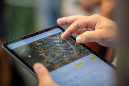
In digital systems such as Geographic Information Systems (GIS), this information is consolidated and analyzed using artificial intelligence. As a result, forestry professionals now have access to reliable decision-making bases for planning, management, and monitoring—ranging from ecological to economic indicators across the entire value chain.
Areas of application for digitalization in forestry include:
The market for digital solutions continues to grow as part of Forest 4.0. One of the key drivers behind this development is startups: with their high pace of innovation and fresh ways of thinking, they are developing practical and forward-looking solutions specifically tailored to the digitalization of forestry.
At INTERFORST, you will find numerous young companies in the Start-Up Area presenting their visionary ideas and new approaches for the forestry sector. Stop by and discover the latest trends in forestry!
Discover the Start-Up AreaDigital tree species selection, AI-based bark beetle detection, digital log stack measurement, drone mapping—or even the integration of the entire timber supply chain? All of this is already possible in today’s forestry practice thanks to Forestry 4.0. With a smartphone or tablet in hand, data can be captured and accessed directly in the forest: master data, key performance indicators, and graphical analyses are available at the touch of a button.
The added value of digital tools is particularly evident in forest management: fewer manual inspections, earlier damage detection, cost savings, and improved adaptation to climate change. All stakeholders involved in a forestry project can be digitally connected. Enhanced documentation and planning help preserve institutional knowledge and mitigate the impact of staff turnover or absences.
Digital solutions are now being used in nearly all areas of forestry, including:
With just a few clicks you can buy your personal ticket to INTERFORST or redeem a voucher.
Simply put, a digital twin is a virtual replica of the forest that is continuously updated with new data and makes changes visible over time. It enables forestry professionals to monitor the condition of their forests, identify trends, and use simulations to assess how stands may develop in the future. For example, it is possible to model how rising temperatures, drought, or changes in water availability could affect a specific site—and which management adjustments might be appropriate.
In addition to digital twins, satellite-based applications open up further opportunities for data-driven forest management. Satellite-supported maps can capture the health status of trees, for instance by measuring the chlorophyll reflectance of leaves. With the help of artificial intelligence, anomalies in the infrared spectrum can be detected that indicate reduced metabolic activity—caused, for example, by drought stress or bark beetle infestation. In this way, early damage detection and well-founded risk assessments become possible, such as in the case of storm events, wildfire risk, or large-scale declines in forest vitality.
Digital tools form the foundation of forestry’s digital transformation. They are used both as standalone solutions and as part of integrated systems: sensors continuously measure environmental conditions, drones capture large-scale, high-resolution data, satellites provide information on stand development and damage assessment, and artificial intelligence analyzes this data to identify patterns. This gives forest enterprises a reliable basis for making and communicating decisions in a transparent, data-driven manner—even across operational boundaries.
Geographic Information Systems (GIS) are used to capture and analyze spatial data in forests, for example in the form of maps. They help identify patterns and relationships within geographic information by linking different data layers (such as images, features, and tables).
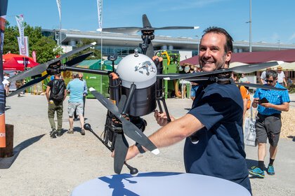
Drones use multispectral cameras and LiDAR technology with laser scanning. Their added value includes forest inventories and stand assessments, damage monitoring, reforestation and maintenance, as well as road and infrastructure inspection.
Satellite imagery is a tool for large-scale monitoring, damage analysis, and tracking stand development. It enables, for example, the early detection of pest infestations, mapping of storm damage and wildfires, and monitoring of tree vitality in the context of climate change.
Sensor technology and Internet of Things (IoT) systems in forests can measure soil moisture and temperature, air humidity and temperature, CO₂ levels, tree growth and water stress, as well as acoustic signals—such as up to 10,000 animal calls. They provide insights into forest biodiversity and its surrounding environment, for example by enabling early detection of drought stress and supporting wildfire prevention.
Artificial intelligence (AI) serves as the central “superbrain” key technology in digitalization. It enables the intelligent integration and analysis of data—for example, for automated tree species and pest detection, risk forecasting (such as drought, storm, or fire risks), and optimized timber utilization.
Despite all the enthusiasm for the technical possibilities of digitalization in forestry, significant challenges remain in practical implementation. Even digitally savvy forestry professionals face partially underdeveloped or lacking infrastructure in forest areas, as well as limited acceptance and insufficient qualifications among stakeholders. Additional obstacles may include inadequate data quality or standards, funding constraints, and legal uncertainties at the federal and EU levels.
To successfully implement digital solutions in the spirit of Forestry 4.0, well-founded information, the exchange of experience, and close collaboration among all stakeholders are essential. This is precisely where INTERFORST comes in: as a central platform for the industry, it provides space for information, dialogue, and professional orientation. Within the supporting program, presentations and discussions from research, academia, and practice highlight current developments in digital forestry, showcase solution approaches, and enable direct exchange between users, experts, and solution providers.
Forestry 4.0 (or Forest 4.0) describes the digital transformation of the forestry and timber industry through modern technologies, data collection, and intelligent data management along the entire value chain.
Smart Forestry refers to the practical implementation of digitalization in forestry through digital tools, research projects, and innovative applications.
The goal is to manage forests more efficiently, sustainably, and in a future-ready way by digitally mapping and optimizing workflows and connecting all stakeholders.
Technologies include drones, satellites, sensor systems, GIS platforms, artificial intelligence (AI), mobile apps, and digital platforms.
AI is the key technology: it analyzes large volumes of data, automates processes, detects damage and risks at an early stage, and supports planning and decision-making.
Challenges include missing or insufficient infrastructure, limited acceptance and qualifications, a lack of data standards, funding constraints, and legal uncertainties.
These include digital management and planning platforms, automated damage detection, remote sensing, sensor systems, digital forest inventories, AI applications, mobile apps, and digital quality assurance in roundwood measurement.
GIS systems capture and analyze spatial data, link different data layers, and support well-informed decision-making—from planning to timber harvesting.
They reduce the need for manual field inspections, lower costs, improve damage detection, support climate adaptation, and elevate documentation and planning to a new level.
A healthy forest for the future thanks to sustainable forestry: reforestation ✓ tree species selection ✓ climate adaptation ✓ biodiversity ➤ learn everything you need to know about healthy forest use!
Forest & People in Focus: Forest Careers ✓ Generational Change ✓ Skilled Labor Shortage ✓ Regional Value Creation ➤ Discover new perspectives!
Innovative forestry technology is shaping the forest of tomorrow. Experience cutting-edge machinery, intelligent systems, and sustainable drive concepts at INTERFORST.